OmniVidi

Perception Service Software Platform
Full Perception, Full Empowerment
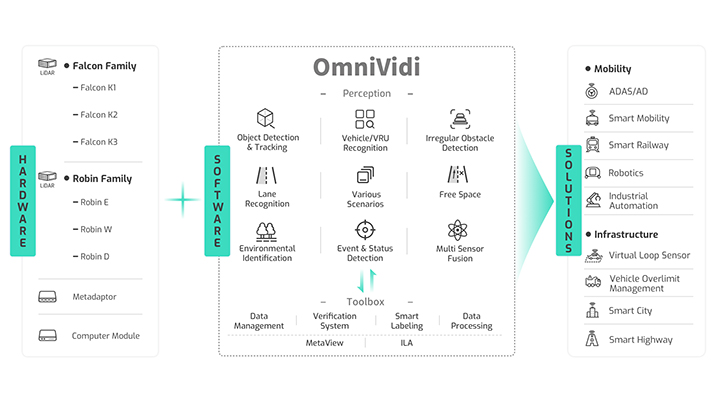
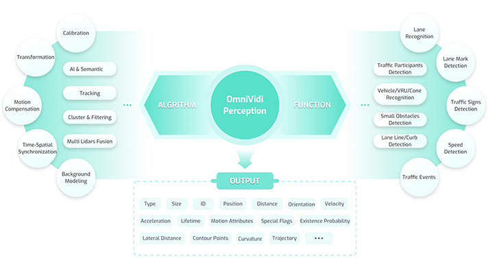
OmniVidi is a comprehensive perception service software platform anchored in LiDAR technology and multi-sensor fusion, encompassing two core modules: the Perception Platform and the Toolchain. The Perception Platform adopts an engineering-focused design philosophy, integrated with state-of-the-art deep learning technological frameworks, providing a wealth of algorithmic model components and perception functionality suites. It offers accurate spatial object information and environmental construction capabilities through traffic participant detection and recognition, traffic event monitoring, and road infrastructure perception. This caters to varied business scenarios such as intelligent driving and smart traffic, fulfilling customer demands with reliable, stable, and user-friendly applications.
OmniVidi Perception Platform
Seyond has developed its own perception platform that covers the entire product line, offering a closed-loop toolchain from data to algorithm model, perception, and verification. By accumulating scenario test cases, it helps customers quickly bring up LiDAR applications.
It provides multiple LiDAR point cloud fusion solutions, achieving feature-level fusion of point cloud targets. This significantly reduces the development workload for external parameter calibration, time synchronization, point cloud calibration, and reflectivity alignment, achieving 360° surround perception in one step.


OmniVidi Toolbox
By building a full-linked data loop that covers data collection, annotation, training, and evaluation, and continuously developing its own automated annotation capabilities, Seyond has significantly reduced annotation costs by 80% compared to manual annotation. This has greatly shortened the delivery chain cycle for obtaining high-quality annotated data. At the same time, the R&D team has accumulated a vast amount of valuable data resources, covering a variety of driving scenarios, and meeting customers’ strict requirements for data diversity and accuracy.
Support for Point Cloud Application
Seyond provides flexible, easy-to-use, and low-threshold support for point cloud applications, catering to various usage scenarios. The ILA, developed based on Web, supports plug-and-play for real-time viewing, recording of point clouds, and parameter configuration. MetaView, developed for clients, meets the more extensive application needs of professional users, offering stronger performance and more comprehensive features for point cloud visualization and interaction, as well as point cloud playback and data analysis.

Ready to Learn More?
At Seyond, we’re pushing the boundaries of LiDAR technology to shape a smarter, safer, and more connected future. Discover how our cutting-edge systems are revolutionizing industries and explore how we can help you achieve your vision.
